The jurisdiction of the office is located in Hualien County, which was known as Qilai and Huilan in ancient times. The area borders the Pacific Ocean to the east and the Central Mountains to the west. It is approximately 138km long from north to south and 43km wide from east to west, covering an area of approximately 4,628km². Geographically it is the largest county in Taiwan, with "Great mountains, great water and great air" the most vivid description for Hualien.
Irrigation water within the jurisdiction mainly comes from rivers, which account for 97.55%; specifically the three main tributaries of the Liwu River, Hualien River and Xiuguluan River system. Management work is extremely difficult. After typhoons and heavy rain, temporary repairs of water barrage facilities are required to ensure farmers have uninterrupted irrigation water.
The business area of the office is within Hualien County and mainly focuses on second-phase rice. The statistical irrigation area in 2010 was 15,563 hectares. In order to reduce the travel of people from north to south and improve the efficiency with which people are served, 8 workstations have been set up under the jurisdiction. From north to south these are Xincheng, Jian, Shoufeng, Fenglin, Guangfu, Ruisui, Yuli and Fuli stations. Yuli station has the largest irrigation area with nearly 3,800 hectares.
By the end of 2019, the total length of irrigation facilities and water transmission projects under the jurisdiction of the Statistics Institute was about 1,650km, with about 212 temporary weirs for water diversion, which were distributed across the long and narrow territory of Hualien County from north to south. The area is adjacent to the Pacific Ocean in the east, which makes the area susceptible to typhoons and other factors, showcasing the difficulties in managing and maintaining office work. However, because the water sources in Hualien are pure and pollution-free, locally grown rice is renowned. In addition, Xincheng sweet potatoes, Jian taro, Wuhe honey black tea etc. are consumer favorites. Although management is challenging, every time office staff see the harvests of local farmers, the hard work is worthwhile.
Hualien County is situated on Taiwan's eastern coast. It's bordered to the north by the Dazhuoshui River in Xiulin Township, which separates it from Yilan County, and stretches southward to Fuli Township. The county is divided into 13 townships and cities. Its terrain is long and narrow, flanked by the Central Mountain Range to the west and the Pacific Ocean to the east. The region is crisscrossed by rivers and benefits from a mild climate with spring-like conditions year-round. It has an average temperature of 23°C and receives approximately 2,000 millimeters of rainfall annually.
The county's farmlands are predominantly composed of gravelly sandy soil, characterized by high permeability, which results in increased water consumption for crops. The average irrigation rate is about 200 hectares per cubic meter per second, significantly lower than in western Taiwan.
While Hualien County covers one-eighth of Taiwan's total area, its irrigated land accounts for only one forty-fifth of the nation's total, amounting to 15,563.41 hectares. The scattered nature of these irrigation areas makes management challenging and expensive.
The Hualien River, the Xiuguluan River, and their tributaries serve as the primary sources of irrigation water. The region has numerous small irrigation systems, with farmlands dispersed between the Central Mountain Range and the Coastal Mountain Range. Irrigation channels meander along slopes, featuring 175 water intake points. Only two of these utilize tailwater from Taipower's hydroelectric plants; the remainder depend on temporary diversion facilities from primary and secondary rivers. Heavy rainfall often results in water loss, and restoring water flow is both costly and difficult to maintain.
Hualien County’s 13 townships.
15,563.41 hectares.
The Hualien and Xiuguluan River systems.
- Main Line: 151.75 km
- Lateral Canal: 439.975 km
- Sub-Lateral Canals: 627.33 km
- Ditches: 413.827 km
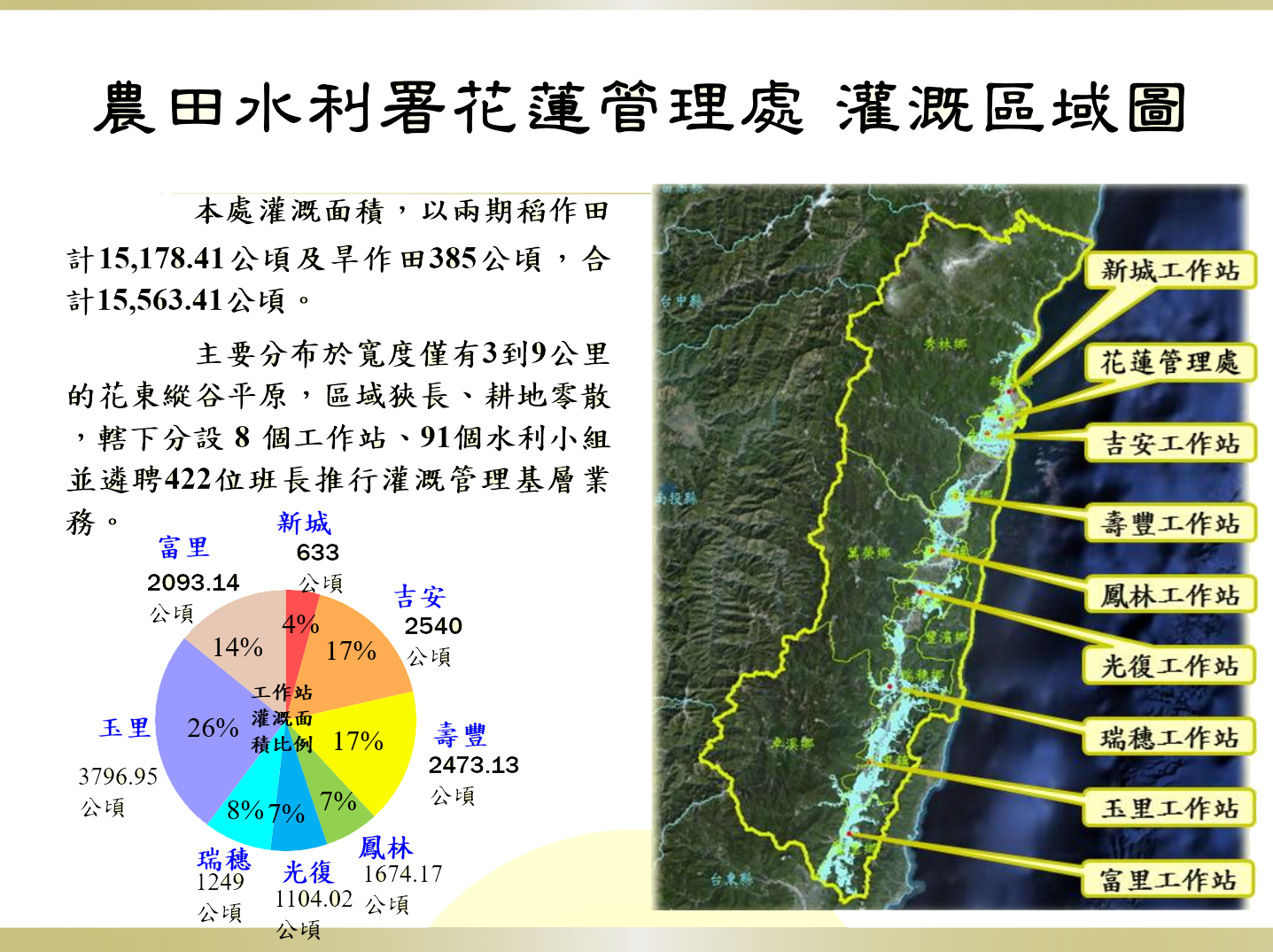
This office manages an irrigated area totaling 15,563.41 hectares, comprising 15,178.41 hectares of rice paddies (cultivated across two growing seasons) and 385 hectares of dry farmland.
The primary farmland is spread across the Huadong Valley Plain, which ranges from only 3 to 9 km in width. Due to the region's narrow geography, the farmland is fragmented. The office operates through eight workstations and 91 irrigation groups. It has appointed 422 irrigation unit leaders to carry out grassroots irrigation management duties.